 by
by Wildfires in California spread quickly Tuesday as firefighters battled strong winds, dry conditions and a heat wave that sent temperatures soaring into the triple digits in the Los Angeles area. However, there may be some relief soon from cooler weather in the forecast.
Firefighters were also battling a blaze in hazardous, windy conditions in western Nevada, just south of Reno.
The National Weather Service issued a red flag warning for most of Nevada and parts of Southern California, indicating that much of the landscape was ready to burn. In Southern California, the Bridge Fire exploded from about 4,000 acres to more than 34,000 acres, and San Bernardino County said homes were lost.
The fires are an added strain in an already busy season for firefighters across the Western U.S. Nearly 7 million acres have already burned, more than double the area last year. More than 24,000 fire personnel were at work on Tuesday.
65,000 structures are threatened by the Line Fire in California
Containment of the Line Fire, which is burning in the foothills of the San Bernardino National Forest and is threatening more than 65,000 homes and other structures, increased to 14% on Tuesday.
But its size had grown to about 32,905 acres as of Tuesday night, according to the California Department of Forestry and Fire Protection (CalFire).
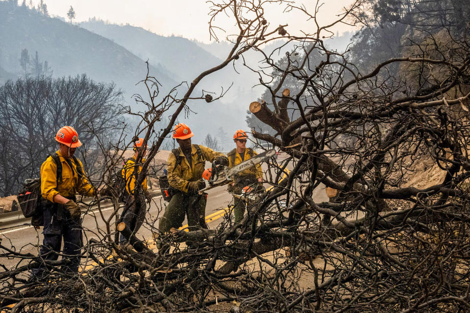
The fire, which started Thursday night east of Los Angeles, forced evacuation notices across an area with 9,200 structures, most of them homes, said Arnold Menjivar, a fire information officer.
Menjivar said the fire was burning closest to homes in Running Spring, a gateway community to Big Bear Lake and Bear Mountain ski resort.
“It’s very close,” Menjivar said, adding that firefighters had an aggressive attack strategy but were concerned about winds blowing through the canyons. “We have very complex terrain here.”
The Line Fire created its own weather system on Saturday, producing thunderstorm-like pyrocumulus clouds, or fire clouds. These develop when fires are so intense that they generate their own weather patterns. The clouds were responsible for at least 280 lightning strikes that hit the ground, the National Weather Service said.
Pyrocumulus clouds were also seen around two other large fires in Southern California: the Airport Fire in Orange County and the Bridge Fire in Angeles National Forest.
A heat wave in Southern California saw temperatures in the triple digits, with red flag warnings around the Fire Line on Tuesday, but cooler temperatures are expected on Wednesday.
That relief could “moderate fire activity and increase fuel moisture,” CalFire said.
The Gov. issued Gavin Newsom state of emergency because of the Fire Line on Saturday. On Monday, fire officials said the California National Guard would deploy four Blackhawk helicopters and other aircraft to assist with modular airborne firefighting systems, as well as 80 soldiers. Nearly 2,100 fire personnel were responding to the fire.
Evacuation orders are in effect for eastern parts of Highland, California, a suburb of San Bernardino, as well as several foothill towns on the roads up to Big Bear Lake. Bear Valley Unified and Redlands Unified school districts closed schools Monday and Tuesday because of the fire.
More blazes in Southern California
The hot, dry weather has also fueled fires in other Southern California hillside communities, forcing additional evacuations.
The Airport Fire started Monday afternoon as a 7-acre brush fire in Trabuco Canyon in Orange County, south of Los Angeles. In a few hours, it exploded to about 5,400 acres, said the OC Fire Authority. As of Tuesday morning it was over 9,000 acres, the fire authority said on X.
The fire was first reported near an airfield used by hobbyists for remote control airplanes. On its website, a local flying club called Trabuco Flyers said no remote-controlled aircraft were flying when the fire started.
The fire prompted mandatory evacuations for the communities of Robinson Ranch and the Trabuco Highlands, as well as evacuation warnings in other nearby communities.
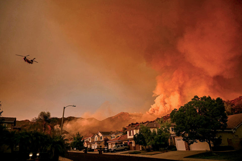
Meanwhile, the Bridge Fire that sparked Saturday in the Angeles National Forest, east of Los Angeles, grew from just under 4,000 acres at 11 a.m. Tuesday to 34,240 acres by Tuesday afternoon, officials said.
“Tragically, homes have been lost,” the San Bernardino County government said on Facebook late Tuesday.
The fire is 0% contained, and its cause is being investigated.
An evacuation order is in effect for residents north of San Antonio Dam up to Mount Baldy Resort, as well as other communities. Wrightwood was also under a mandatory evacuation order Tuesday night.
“There has been significant growth in wildfires throughout the day,” Los Angeles County Fire Chief Anthony Marrone said at a Tuesday evening news conference.
The fire affected Mount Baldy and the Wrightwood community, he said. Video shared online by the San Bernardino County Fire Protection District showed firefighters rushing to provide rescues of about 4,700 to the public.
The three wildfires burning in Southern California at the same time – the Line Fire, the Bridge Fire and the Airport Fire in Orange County – are stretching firefighters thin, and they are looking for help from Northern California and neighboring states manual, said Marrone.
“We urge everyone under an evacuation order to leave now,” Marrone said at a 7 p.m. PT briefing. Those under evacuation warnings should prepare to leave “at a moment’s notice,” he said.
Dangerous conditions in the Sierra Nevada foothills
Winds and dry conditions alerted firefighters near Reno, Nevada, where the Davis Fire had burned nearly 5,600 acres. It was 0%, according to Tuesday’s status update.
The fire started around Davis Creek Regional Park, just south of Reno, on Saturday, and was burning heavy wood and brush. It affected at least 14 structures, prompted road closures and put an estimated 12,000 to 14,000 people under an evacuation notice.
More than 400 personnel are working on the fire. The El Dorado County Fire Protection District shared videos on social media of bright flames burning up wooded mountains and thick plumes of smoke filling the air.
Actor Jeremy Renner was one of the many locals affected by the Davis fire. On Sunday, he shared an Instagram story showing a huge cloud of smoke billowing from the mountains, People Magazine reported. He shared more photos on Tuesday showing firefighters at work and planes dropping pink fire retardant.
Tuesday will be the last day of high temperatures in the areas where the most concerned fires are burning in Nevada and Southern California.
On Wednesday, a cooling flow from the Pacific Ocean is expected to drop temperatures 10 to 15 degrees Fahrenheit in Southern California.
A cold front is expected to drop into the Reno area on Wednesday as well, but that’s not necessarily good news for the fires as it could improve winds.
Mountaintop gusts could reach 50 mph in wind-prone areas there, according to the National Weather Service forecast.
This article was originally published on NBCNews.com