 by
by More than 14 million leisure trips will be made this Easter weekend, with Good Friday forecast to see the worst traffic congestion and the Lake District, south coast and West End.
The RAC predicts that more than 2.6 million journeys will be made on Friday alone. This is 600,000 more than the day before, on Thursday, when many schools break up.
The wet conditions could lead to further delays, with the AA warning: “As well as standing water and slippery streets, drivers should remember that stopping distances increase when there is rain and when vehicles are moving more weight.”
Anyone traveling by car should be prepared to hit some traffic this weekend, but smart decisions can be made to avoid the worst of it. Here are the best times to leave, the petrol stations to avoid, and the little engine checks that could help you avoid disaster.
What is the best time to leave home?
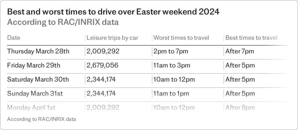
It depends on how long your drive is and where you are going. But in general, the worst time to be on the road is mid-day (between 10am and 2pm) and the best time to hit the road is after 5pm.
The RAC breaks it down a bit more (see table below). Their analysis shows that anyone hoping to get ahead of weekend traffic by traveling on a Thursday should leave early in the morning or later in the evening, avoiding 2pm to 7pm if possible. This is because the traffic is expected to leave early on Thursday at odds with their normal commute.
On Friday, the worst jams are expected at 11am, so it would be wise to work backwards and calculate your departure time accordingly. The RAC says: “Drivers are advised to start their journeys as early as possible in the morning or delay them until later in the afternoon.”
Frank Bird, senior network planner at National Highways, explains why this dedication can pay off: “When I travel to see the people in Scotland I’m on the road at 4.45am – so traveling from Brum to the border by 8am. Then [I take a] 20 minute break and get back in full swing – then in Aberbroth at 11.30am and have a fish supper at noon on the harbour.”
Which motorways are the worst for traffic?
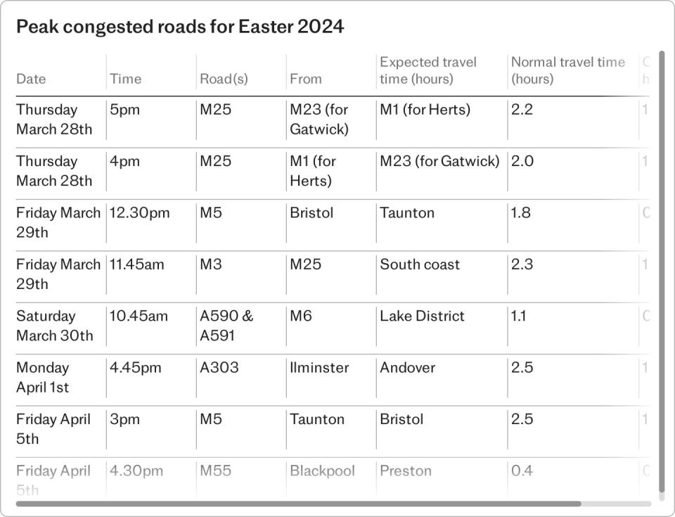
On Thursday evening (around 5pm), the busiest road for traffic is the westbound section of the M25 between the M23 (for Gatwick) and the M1 (for Hertfordshire). The traffic time is expected to exceed two hours, which is more than double the normal time. Northbound and southbound cars will be equally delayed along this western half of the M25.
On Friday, the roads to avoid are the M5 (from Bristol to Taunton) at around 12.30pm, when journey times will take around twice as long as expected. There will be heavy traffic on the M3, from the M25 to the south coast, from 11.45am and is expected to take at least an hour longer than usual.
On Saturdays, the worst congested roads are the A590 and A591 from the M6 to the Lake District, with delays of half an hour on average along the route.
For the return leg, on Easter Monday, the road with the worst traffic forecast is the A303 from Ilminster to Andover from 4.45pm, when journey times will double to around 2 hours 30 minutes. On the changeover day at the end of the week, April 5, the M5 from Taunton to Bristol will be the worst affected by delays, as will the M55 from Blackpool to Breston.
National Highways also says that roads close to ports and airports can expect delays. “If you are traveling to Dover or Eurotunnel we have been working with the port authorities and customs, but we are expecting some delays and there may be disruption to locations,” a spokesman said.
Which is the best mapping app?
The two main navigation apps, Google Maps and Waze, are owned by Google, but they are separate products and work differently. Waze uses smart rerouting tactics to help you get to your destination as quickly as possible – however, sometimes using elaborate diversions can shave off a minute or two of your drive. Google Maps also reroutes to avoid heavy traffic, but puts the decision in your hands.
The main difference between the two is that Waze relies on active users on the road at that moment to imagine traffic conditions, whereas Google looks at historical data and uses traffic sensors to predict the fastest route. Google Maps and Waze both alert you to localized traffic updates and road hazards, but Waze generally has more speed camera alerts along major roads. The only fault Waze users have is that it’s not as efficient when driving in remote areas with little traffic, but that shouldn’t be a problem in the UK this weekend.
Apple Maps is a very similar product to Google Maps, accessible only to iPhone users, but due to differences in the way the two firms process user data, Google has a greater ability to offer real-time updates in a way Apple can’t.
Frank Bird from National Highways suggests that if satellite navigation is being used in the car, it’s worth making sure it’s up to date. He also recommends listening to traffic and travel updates on the radio along the way.
What is the average petrol mark up?
The average price of unleaded petrol across the UK is 145.50p; the average price at a motorway service station is 168.54c per litre. This means that filling an average 50 liter tank of fuel at your local service station will cost £72.75, but filling up on the motorway will cost £84.27 – a difference of £11.50. The discrepancy for diesel cars is similar – 153.19p across the UK, compared to 177.23p at motorway service station pumps.
According to data pulled by the AA this week, two of the most expensive pumps in the country are at Cobham on the M25 (172.9p for petrol) and Tibshelf between junctions 28 and 29 on the M1 (172.9p).
National Highways recommends always filling up when you reach a quarter of a tank. “It’s not worth the risk or expense of running out and ruining the holiday,” he advises.
Three critical engine checks
Chris Wood, who was named AA Patroller of the Year for his roadside recovery work, says: “Take 10 minutes to check your oil, coolant and windscreen washer levels. It’s also important to make sure you have plenty of fuel or electrical charge and check that all your lights are working.” The RAC has a handy page with videos, explaining how to run these checks.
“Check your tire pressures – do this when the tires are cold and don’t forget to check the tread – including the extra pressure if your vehicle has one,” says Chris Wood.
“If driving in wet weather, try to avoid standing water where it is safe to do so, as this may cover holes or dislodged inspection covers that may be lying beneath the surface .”
The AA also recommends that members download the What3Words app before travelling, as this is the easiest way to describe an exact location – identifying where you are within three metres.