 by
by CNN’s Original Series “Violent Earth With Liev Schreiber” examines extreme weather events, such as hurricanes and wildfires, that are becoming more frequent in our changing climate. The latest episode will air at 9 pm ET/PT on Sunday.
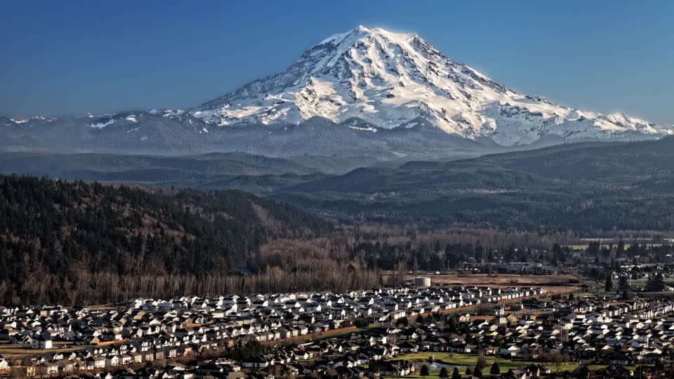
The snowy peak of Mount Rainier, which towers 4.3 kilometers (2.7 miles) above sea level in Washington state, has not experienced a significant volcanic eruption in the past 1,000 years. However, more than Hawaii’s bubbling lava fields or Yellowstone’s sprawling super crater, it is Mount Rainier that worries many US volcanologists.
“Mount Rainier keeps me up at night because it’s such a threat to the surrounding communities. Tacoma and South Seattle are built on 100-foot-thick (30.5-meter) ancient mudflows from Mount Rainier eruptions,” said Jess Phoenix, a volcanologist and ambassador for the Union of Concerned Scientists, on an episode of “Violent Earth With Liv Schreiber,” CNN Original Series.
The destructive potential of the sleeping giant is not limited to fiery lava flows, which, in the event of an eruption, are unlikely to extend more than a few miles beyond the border of Mount Rainier National Park in the Pacific Northwest. And most of the volcanic ash would likely be dispersed by wind east of population centers, according to the US Geological Survey.
Instead, many scientists fear a lahar — a fast-moving slurry of water and volcanic rock that erupts from rapidly melting ice or snow that stirs up debris as it flows through valleys and drainage channels.
“What makes Mount Rainier tough is that it’s so high, and it’s covered in ice and snow, so if there’s any eruptive activity, the hot stuff … the cold stuff will melt and start lots of water coming. down,” said Seth Moran, a research seismologist at the USGS Cascades Volcano Observatory in Vancouver, Washington.
“And there are thousands, if not hundreds of thousands of people who live in areas that could be affected by a large lahar, and it could happen quickly.”
A lahar is a fast-moving debris flow
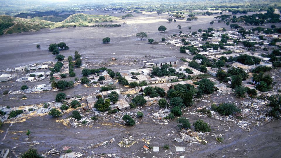
The deadliest recent lahar was in November 1985 when Colombia’s Nevado del Ruiz volcano erupted. Just a few hours after the eruption began, a river of mud, rocks, lava and icy water swept over the town of Armero, killing over 23,000 people in a matter of minutes.
“When it comes to rest … you have this hardened substance that’s almost, like, this concrete substance that can be, like, quicksand when people want to get out of it,” Bradley Pitcher, volcanologist and lecturer in earth and environmental sciences at Columbia University, said in an episode of CNN’s “Violent Earth.”
Pitcher said Mount Rainier had about eight times as much glacier and snow as Nevado del Ruiz when it erupted. “There is the potential for a much more catastrophic mudflow.”
In the U.S. Geological Survey’s latest threat assessment from 2018, the federal agency rated Hawaii’s Kīlauea as the U.S.’s most dangerous volcano—not surprising given how many people live near it and how often it erupts. it is erupting. Mount St. was ranked Helens, which erupted cataclysmically in May 1980, as the second most dangerous place before Mount Rainier in third place.
Past eruptions reveal multiple mudflows
Lahars usually occur during volcanic eruptions but can also be caused by landslides and earthquakes. Geologists have found evidence that at least 11 large lahars from Mount Rainier have entered the surrounding area, known as the Puget Lowlands, in the past 6,000 years, Moran said.
Scientists have not linked the most recent of these lahars, which occurred about 500 years ago, to any type of volcanic activity. According to researchers, the flow event may have been caused by a large landslide on the western side of the mountain.
Loose, weak rock remains in that spot, and it’s the threat of a similar spontaneous lahar landslide that particularly troubles Moran and other ecologists.
“There is now information that the volcano could do it again. And then we’re in this world where it could happen at any time,” Moran said.
“If it was the same size, then it would be 10 minutes to the nearest inhabited places, and 60 minutes to the nearest large communities. And those are really short time frames,” he said.
Two worst-case scenarios were modeled in a study in 2022. In the first simulation, a 260-million-cubic-meter, 4-meter-deep (9.2 billion-cubic-foot, 13-foot-deep) lahar would erupt on the west side of Mount Rainier. The debris flow would be the equivalent of 104,000 Olympic-sized swimming pools, according to Moran, and could reach the densely populated lowlands of Orting, Washington, about an hour after the eruption, where it would travel at a speed of 13 feet (4 meters) per second.
A second area of ”pronounced danger” is the Nisqually River Valley, where a massive lahar could displace enough water from Alder Lake to spill the 100-meter-tall (330-foot-tall) Alder Dam, according to the simulation . .
A lahar who lives
Mount Rainier’s cousin Mount St. Helens, further south in the Cascade Range, a devastating lahar when it erupted four decades ago, although it did not reach any densely populated areas.
Venus Dergan and her boyfriend at the time, Roald Reitan, were arrested in Mount St. Helens during a camping trip and are two of the few people we know of who survived being swept away in a debris flow.
“I tried to hang on as we were being swept downstream, the bark on the trees was just scraping. … I could feel it on my feet, on my hands,” she said during an interview for CNN’s “Violent Earth.”
“And at one point, I went under the logs and the mud, and I just resigned myself to this. I wasn’t going to get out of here and I was going to die.”
Reitan managed to lift her out of the mudflow, and they rode a huge log down the river. When the log came to an end, they jumped on an embankment and went up the side of a hill, where they were rescued. It took Dergan two years to fully recover from his injuries.
The world’s largest lahar evacuation drill
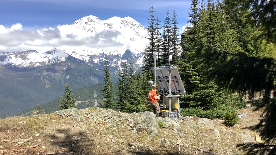
After the eruption of Mount St. Helens, the US Geological Survey established a lahar detection system at Mount Rainier in 1998, which has been upgraded and expanded since 2017.
About 20 sites on the slopes of the volcano and the two paths identified as the greatest danger from lahar have broadband seismometers that transmit real-time data and other sensors including trip wires, infrasound sensors, web cameras and GPS receivers.
The system is aimed at detecting lahar should the volcano rise in the future and the specific case of lahar triggered by a landslide, Moran said.
The original system had low bandwidth and low power requirements due to the limitations of 1990s era technology, which meant that data was only transmitted every two minutes.
There is a lack of historical reference data since there are few lahars worldwide that have been recorded by monitoring stations, so a wider range of instruments will help to determine if a seismic signal received from one of the stations actually comes from a debris flow, and not from an eruption or earthquake, Moran said.
Infrasound instruments, for example, would tell the researchers that there was a disturbance at the surface of the earth rather than deeper in the earth.
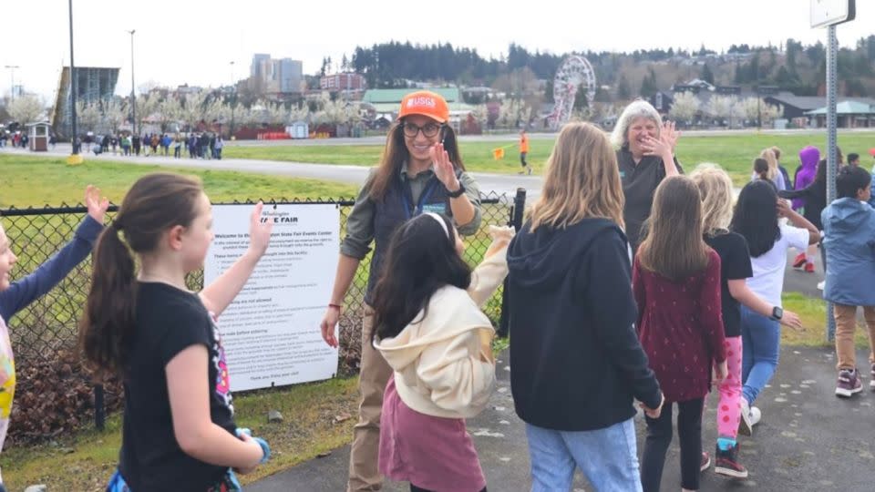
In March, approximately 45,000 students from Puyallup, Sumner-Bonney Lake, Orting, White River and Carbonado, Washington, participated in a lahar evacuation drill. It was the first time multiple school districts practiced on the same day, making it the largest lahar drill in the world, according to the USGS.
About 13,000 students walked up to 3.2 kilometers (2 miles) to designated locations outside the mapped lahar zone, while the rest took shelter in schools outside the lahar zone.
Moran said the fail-safe parts of the lahar detection system are located about 45 minutes from the nearest large community, making it the time frame communities had to work with.
“Most things that happen at volcanoes are nearby, that’s why you try to keep people away because things happen quickly, but lahars can travel a long way from the volcano and have a big impact to have.”
Sign up for CNN’s Wonder Theory science newsletter. Explore the universe with news on exciting discoveries, scientific advances and more.
For more CNN news and newsletters create an account at CNN.com