 by
by Mangroves are one of the most important ecosystems on the world’s coasts. They absorb the impact of storms, prevent erosion, provide food and safety for fish and other animals and can store vast amounts of carbon in the mud that accumulates beneath them.
However, due to their sensitive location in the transition zone between land and sea, they also face a number of man-made threats, such as pollution and sea level rise due to climate change.
That is why it is essential to obtain up-to-date and accurate information on the location and extent of mangrove forests in order to conserve and manage them more effectively. In our latest research, we used images captured by Earth orbiting satellites to map the past and present mangrove cover on the tropical island of Mauritius.
Islands are particularly vulnerable to climate change, especially its sea-related effects, such as rising sea levels or increasingly powerful hurricanes. Like many other small islands, Mauritius relies heavily on its coast as a source of income. That’s why being able to take quick action to protect oneself and handle the impacts of climate change is vital.
Mangroves have long been recognized as a natural way to mitigate such threats. We used readily available satellite imagery to track them in Mauritius, which could help support the island’s efforts to adapt to a changing climate.
Satellites to monitor mangroves
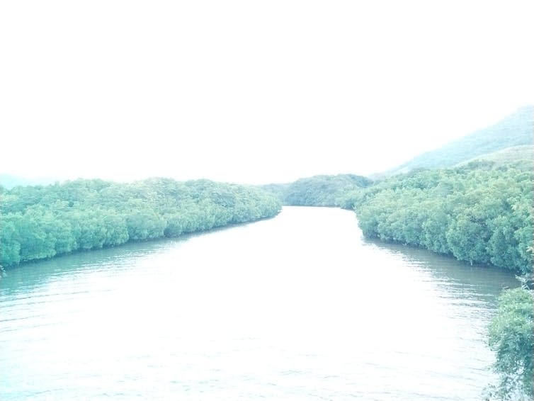
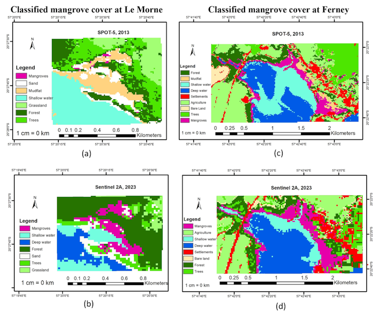
We collected mangrove GPS coordinates at two locations, Le Morne in the south and Ferney in the southeast. Le Morne is a new mangrove planting site within sandy beaches. Mangroves at Ferney have grown naturally, are mature and grow mainly on the muddy banks of the Champagne.
We then retrieved free satellite images from the Earth orbiting satellites SPOT-5 for the year 2013 and Sentinel 2A for 2023. We analyzed the data with easy-to-use software that required no programming skills. We trained and tested our model using the field data we collected and obtained results with 90% accuracy and higher compared to data collected on the ground.
With the satellite images, we found that the mangrove cover at Le Morne increased significantly from 0.06 hectares (ha) in 2013 to 4.6 hectares in 2023. This was as expected: it is an active mangrove plantation and it is there for many years. Our results are consistent with the actual size of the mangroves measured by people at the site.
At Ferney, we also observed an increase from 20.8 ha in 2013 to 26.3 ha in 2023. Here, we attribute the increase to natural regeneration taking place in the nearby mudflats.
The technique we used in this study shows that satellite imagery and graphics software can do an effective job of mapping mangroves across a landscape. This can provide useful insights to support decision-making to increase resilience to climate change.
Why the study is important
In general, ecosystem monitoring using satellite imagery is still in its infancy in island nations such as Mauritius. This is due to several challenges especially the lack of human expertise and programming skills among biologists.
But if we can address these issues, we can use satellite imagery to gain critical information. For example, satellites can detect changes – such as the forest growing, shrinking or thinning – earlier than might be apparent from the ground. Satellites equipped with radar or specialized sensors can measure the height and structure of forests, which can provide valuable information on biomass density and thus how much carbon the forest can store.
Satellite imagery can also help local people participate in restoration efforts and can help scientists map changes along the coast and assess how vulnerable mangroves may be.
When we monitor mangroves using such techniques, we can become more resilient to climate change. Overall, our study demonstrates how a technology such as satellite imagery analysis can provide precise, repeatable and cost-effective monitoring of mangroves.
Don’t have the time to read about climate change as much as you’d like?
Get weekly salvation in your inbox instead. Every Wednesday, The Conversation’s environmental editor writes Imagine, a short email that goes a little deeper into one climate issue. Get in touch with the 30,000+ readers who have subscribed so far.
This article from The Conversation is republished under a Creative Commons license. Read the original article.

This work was supported by the RECOS project of the Indian Ocean Commission, funded by the French Development Agency (AFD) and the French Global Environment Facility (FFEM).
Co-Director – NA – SPIDER (United Nations Space-Based Information Platform for Disaster Management and Emergency Response) – UK Regional Support Office, University of Central Lancashire, Preston, United Kingdom